Overview of the river Nile Basin
I will predominantly be writing about political issues in the Nile river basin throughout my blog. Ever since learning about Ancient Egypt and subsequently the River Nile as part of the classic school curriculum, news about the region has piqued my interest. For that reason, when deciding upon a focus area for my blog, the Nile basin immediately sprang to mind. This is a great opportunity to study the region to a greater depth and from a broader perspective. The Nile is also fascinating to study due to the sheer scale of its basin and its importance on the economies, livelihoods and politics of its riparian countries (Wiebe, 2001). For example, for Egypt and Sudan, about 97% and 77% respectively of their freshwater stems from the Nile (Wiebe, 2001). There are few alternatives from which to supply the agricultural, industrial and domestic water requirements.
First I have included a short video outlining the importance of the Nile:
Geography of the Nile
The Nile River is arguably the longest river system in the world (some claim this title belongs to the Amazon river), flowing for 6670km northwards through north east Africa before draining into the Mediterranean Sea, as shown in Figure 1 (Koutsoyiannis et al., 2008.). It runs through 11 countries: Egypt, Sudan, Ethiopia, Kenya, Uganda, Tanzania, Democratic Republic of Congo, Rwanda, Burundi, Eritrea, and South Sudan (Mwaniki, 2018). The drainage basin of the Nile covers a vast expanse of land; adding up to about 10% of the African continent (Swain, 2010). The main river forms at Khartoum which is the capital of Sudan. This is the convergence point of the 2 major tributaries of the Nile; the Blue Nile and the White Nile (Figure 2).
The White Nile is the longest of the tributaries, originating in Burundi and travelling through the Great Lakes region of Central and East Africa through Tanzania, Uganda and South Sudan before converging with the Blue Nile in Khartoum (Mwaniki, 2018). It also flows through 3 of the equatorial lakes: lake Kyoga, Mobutu and Victoria which is the 2nd largest fresh water lake on earth in terms of area.
The Blue Nile originates in the Ethiopian Highlands and is the major water supplier of the 2 tributaries, contributing 59% of the flow (Swain, 2010). The Ethiopian Highlands are of great importance as the rivers and waterways in the region provide the Nile with 86% of its flow (Swain, 2010). However, these tributaries in the Highlands are prone to fluctuations throughout the year significantly impacting the volume of the Nile with large flow variation between the wet and dry seasons.
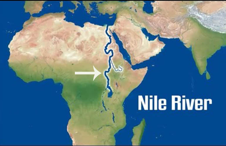 |
Figure 1: position of the Nile in relation to the rest of the continent Source: cleopatraegypttours, 2021 |
 |
Figure 2: map of the river Nile & its 2 main tributaries Source: Abd Ellah, 2020 |
Importance of the Nile
The river Nile was vital for the development and survival of ancient civilisations in the region. They were entirely dependent on its waters for cultivation and transportation (National Geographic). Due to the annual flooding which deposits silt, the land alongside the river has extremely fertile soils (Figure 3). Consequently, people have been settling on its banks for millennia. Today, the river remains equally as important for trade and transportation routes and an essential source of irrigation for the agricultural economies of the region (National Geographic). The river is also a key source for hydroelectric power which will play an ever increasing role in the politics of the region.
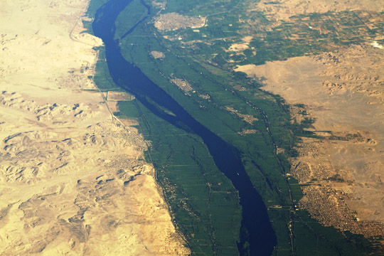 |
Figure 3: Birdseye view of the Nile, showing the fertile area along the banks Source: rivendellschool |
The Nile Basin countries have experienced rapid population growth recently with a total population of over 400 million (Swain, 2010). This has put a great strain on the resources of the Nile as over 50% of these people are dependent on its waters for their water supply (Swain, 2010). As a direct result, the amount of water available per capita is decreasing.
The uneven distribution of surface water in the basin only exacerbates the supply issues and is a key factor for many of the political tensions between the Nile riparians. The general trend is that the upstream countries in the Great Lakes area have a plentiful supply, whereas the downstream riparians have a scarce supply of water as well as having much more arid climates, causing water insecurity.
The economies of the basin countries are primarily agricultural which is a very water intensive sector. The agricultural sector is responsible for 86% of water withdrawal in Egypt and Ethiopia, and 94 % in Sudan (Mason, 2004). Irrigation is essential to meet the needs of the growing populations and provide food security.
Due to the growing populations, uneven water distribution, varying climates and increasing irrigation needs, a cooperative approach to sharing the Nile water is needed. However, due to the power dynamics of the region, equitable use of the Nile has not always been the reality, resulting in distrust and political instability (Merem et al., 2020). In future posts I will be looking further into the political issues related to water sharing that are associated with transboundary river systems by examining the Nile Basin.


Reading the beginning of your blog filled me with nostalgia - thinking back to secondary school Geography, I miss it haha! Your blog really points out the significant aspects we weren’t taught during that pre-sixth form/university period and I think it’s really important to inform people on them as you are above.
ReplyDeleteI miss those days too take me back! I thought a brief bit of general knowledge would be helpful for understanding the more complex topics to come
DeleteVery well judged blog post this. A good signpost for the excellent topics to come.
ReplyDeleteThanks Charlie, clear directions are always useful!
Delete